
The day after our trip to the end of the road, we took a shuttle from our hotel to a heliport, climbed into a helicopter, and flew over the part of north Hawaii Island where King Kamehameha was born in the mid-eighteenth century. (Click on images to see them alone.)

Of course, he wasn’t a king in those days. He was just another islander, albeit a special one, growing up in a rugged, roadless region, a region that remains mysterious and inaccessible today.

The habitat there is very different from where we were staying. When we took off, all we could see was an arid smooth landscape. The dry ground (which is lava cinder) barely supported grass and a few scruffy trees.

Just like on the Great Plains, trees were clustered in gullies where rainwater ran.

As we flew north, we could see signs of tectonic activity, like this great deep fissure extending as far as the eye could see.

We soon approached ruins of the extinct volcano whose eruptions over hundreds of thousands of years had created the landscape we were seeing. Having flown just a few miles, we had crossed into a region of verdant headlands, watered by over 150 cm of rain each year, as clouds rake across this, the most northernmost promontory of the Island of Hawaii.

Long ago, a shifting of the earth’s deep structure sheared away the lava formations, creating the imposing sea cliffs of the North Kohala coast. The sea cliffs are about 1500 feet high.

Wedged between the cliffs are long, steep-sided sea valleys.

Some are narrow and more or less V-shaped;

. . . others are broader, harboring hidden sea plains.

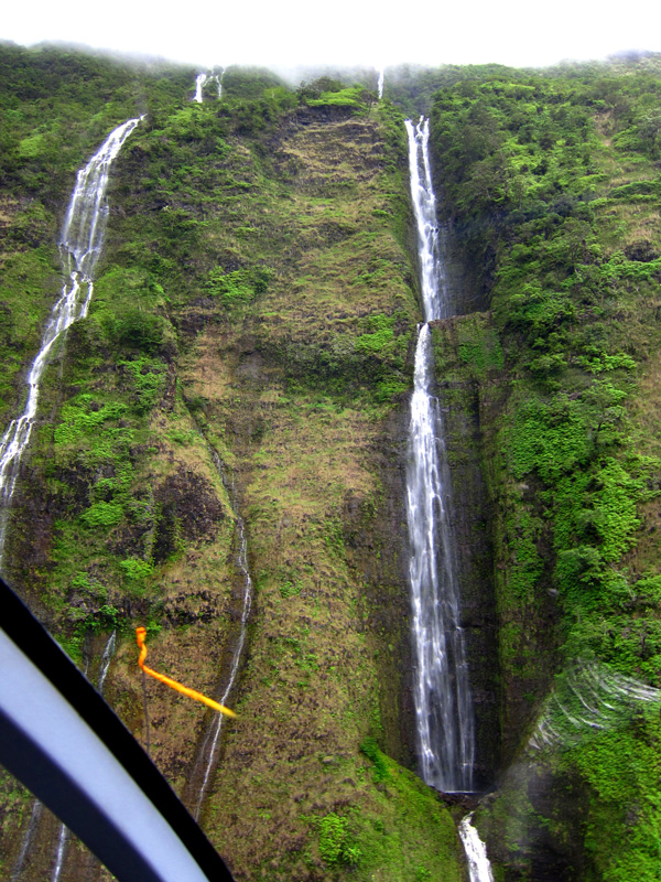
Gushing out from the cliffs and valleys are thin, long, vigorous waterfalls. Seeing them from this angle was really quite strange.

Looking down, we could see the types of vegetation growing all over the cliffs and valleys. In some spots, we could see thick stands of the kului, or candlenut, tree. It’s easy to spot because of its light grey-green leaves. First brought by Polynesian settlers to Hawaii, the candlenut is Hawaii’s official state tree. The tree produces nuts that are flammable. The islanders made torches out of them, and, noticing that the nuts burned at a uniform rate, used them as a means of measuring time. The nuts are also used in making leis.

It was thrilling to see what lay beyond the end of the road. Seeing the abrupt terminus of the road below us brought a sense of completeness to our aerial journey.
A wonderful post ! Gorgeous pictures and informative and well-written captions. Thank you.
A fun way to relive a trip and a truly sensational experience.